
Rock Stabilization at Pompeys Pillar National Monument
Project Description
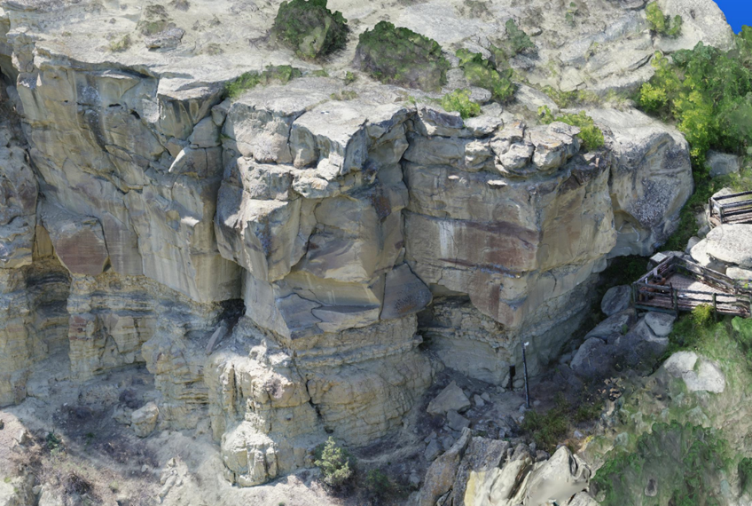
Pompeys Pillar National Monument (PPNM) is a 200-foot-high sandstone outcrop containing hundreds of prehistoric and historic features, including William Clark’s signature, inscribed on the sandstone rock in 1806. Located 30 miles east of Billings, Montana, Pompeys Pillar is a heavily visited attraction with 30,000 visitors each year.
The U.S. Bureau of Land Management (BLM), which manages the site, has identified that the sandstone and shale outcrop, which contains William Clark’s signature (referred to as the Signature Block), is vulnerable to erosion. The condition and higher weathering rate of the shale and siltstone layers could impact the support to the overlying sandstone blocks.
Itasca's Role
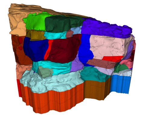
ITASCA was retained by the BLM to assess the stability of the Signature Block and to evaluate remedial measures. ITASCA conducted site and laboratory testing investigations and developed a 3DEC stability assessment model of the critical areas utilizing high-resolution scans, drone-based videography, and photogrammetry of the pillar by Bolton and Menk, Inc.
Stability of the rock blocks were assessed using two methods: 1) incrementally removing siltstone from the face of the outcrop to simulate erosion by weathering; and 2) by performing an overall strength reduction factor (SRF) based on the present geometry. Lastly, siltstone stabilization was modeled. Simulated shotcrete reinforcement was applied to the shale and siltstone.
A design phase instrumentation and monitoring program (including crack gauges, reflectorless electronic distance meters, and tiltmeters) was developed by Barr Engineering and ITASCA to collect a block and joint deformation baseline. ITASCA, in consultation with BLM archeology staff, identified sensor locations. Barr installed the sensors, dataloggers, and telemetry.
Project Results
3DEC modeling of erosion predicted that the blocks would become unstable after 76 to 92 cm of weathering, depending on the block. Shotcrete applied to the shale and siltstone added confinement to these layers and resulted in an increase of the stability of sandstone blocks in the Signature Block area. Simulations using approximately 15 cm thick shotcrete resulted in 2.2 £ SRF > 2.5 , which compares to 1.3 < SRF < 1.6 without shotcrete.
The instrument data is automatically uploaded to a cloud-based host that is accessible via a web interface, allowing for periodic review by BLM staff and their consultants. This also allows for automatic notifications when measurements exceed trigger limits established from baseline measurements.
Based on the 3DEC modeling results along with BLM feedback, remediation recommendations were provided by ITASCA.
References
Brose, A., Peterson, R., & Petersen, L. (2023). Rock Stabilization at Pompeys Pillar National Monument: The Use of Numerical Modeling to Analyze Risk of Failure. 72nd Highway Geology Symposium, Lawrence, Kansas, August.
